Green Belt land in the UK plays a vital role in preserving open countryside, controlling urban sprawl, and protecting natural habitats. Knowing whether your land or property falls within a Green Belt zone is essential for homeowners, developers, and planners. With the 2026 updates to interactive Green Belt maps, it is now easier than ever to check boundaries, understand restrictions, and make informed planning decisions.
These maps provide a clear, visual representation of protected areas, enabling users to search by postcode, explore local boundaries, and see how national and regional planning policies apply. Whether you are considering property development, land investment, or environmental conservation, understanding Green Belt boundaries can prevent costly mistakes and ensure compliance with regulations.
What is the Green Belt?
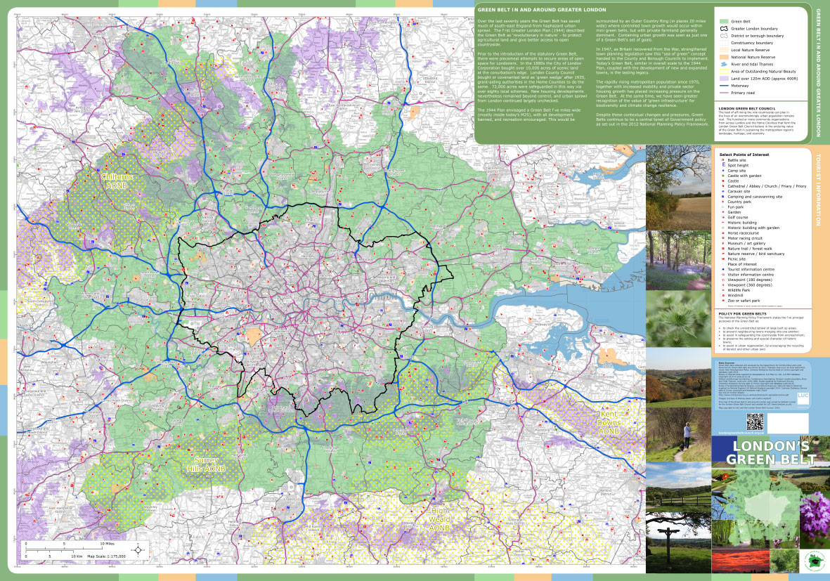
The Green Belt is a planning designation intended to protect the countryside and prevent uncontrolled expansion of towns and cities. Established in the 1930s and expanded after World War II, Green Belt areas form a buffer around urban centres, ensuring that communities do not merge and that open spaces remain preserved.
While Green Belt land may include parks, forests, or recreational spaces, most of it consists of farmland and natural landscapes. Its primary purpose is land-use control, rather than conservation alone. For developers, landowners, and local authorities, mapping these areas is crucial to understanding where construction or development may be limited.
Interactive Green Belt maps allow users to visualize these zones, identify property boundaries, and make informed decisions about land use. For those involved in urban planning or environmental protection, this knowledge is essential to maintain both legal compliance and ecological balance.
Green Belt Planning Rules
Development within the Green Belt is generally restricted under the National Planning Policy Framework (NPPF). Only specific types of projects are usually permitted, such as:
- Agricultural buildings and farm infrastructure
- Recreational facilities like outdoor sports grounds
- Extensions to existing homes under strict size limits
- Infill development in some designated villages
These rules are designed to prevent urban sprawl and maintain the character of rural landscapes. Attempting construction outside these exceptions can result in rejected planning applications and potential legal challenges.
Using a Green Belt map before submitting any planning proposal is a practical first step. It allows landowners and developers to see the precise boundaries of protected zones, helping to avoid unnecessary delays or disputes with local planning authorities.
2026 Updates: Grey Belt and NPPF Changes
![Green Belt Rules: Updated NPPF and What It Means for the Green Belt [2025] - Urbanist Architecture - Small Architecture Company London](https://urbanistarchitecture.co.uk/media/pages/blog/green-belt-rules-nppf/1c10458ae4-1726585357/green-belt-map-1024x.webp)
Recent planning developments have introduced the concept of Grey Belt areas. These zones act as transitional spaces where limited development may be permitted while still protecting core Green Belt regions. Grey Belt policies provide flexibility for housing or community projects in areas that do not fall under strict Green Belt protection.
The 2025–2026 updates to the NPPF also clarify what developments are acceptable. Key changes include:
- Refined definitions of exceptions for agriculture, recreation, and limited housing
- Guidelines for local authorities to assess infill or redevelopment projects
- Updated mapping procedures for public access to Green Belt and Grey Belt zones
By using the latest interactive Green Belt maps, you can ensure that your plans align with the most recent policy updates, reducing risk and improving planning efficiency.
How to Use the Green Belt Map UK 2026
The Green Belt map provides a practical, interactive tool for assessing land boundaries. Follow these steps for accurate results:
- Search by Postcode or Location: Enter your postcode to see whether your property lies within a Green Belt zone.
- Explore Map Layers: Use available layers to view local authority boundaries, planning designations, and environmental features.
- Zoom and Navigate: Examine property and surrounding areas closely for planning assessments.
- Check for Updates: Ensure the data is current by using maps updated for 2026.
This step-by-step approach allows homeowners and developers to make informed decisions and comply with planning requirements effectively. Interactive features such as boundary overlays and region-specific data enhance understanding and reduce errors.
Green Belt Land Across the UK
Green Belt areas are spread throughout the UK, surrounding major cities and towns to preserve open space. Examples include:
- London Green Belt: Extends across multiple counties, creating a significant buffer around the capital. Development is tightly regulated, with limited exceptions.
- Midlands: Green Belt zones around Birmingham, Coventry, and Nottingham aim to prevent towns from merging, while allowing selective development in permitted areas.
- Northern England: Areas near Manchester and Leeds may allow limited housing or agricultural developments on Green Belt fringes, especially where Grey Belt policies apply.
Regional differences in planning policies make it essential to consult both the map and local planning authorities when considering development or land investment.
Can You Build on Green Belt Land?
Building on Green Belt land is generally restricted, but exceptions exist for:
- Agricultural or forestry structures
- Outdoor recreational facilities
- Limited home extensions
- Small-scale infill developments where permitted
Before proceeding, check the Green Belt map to verify your land’s status. If your property is in a Grey Belt area, there may be additional opportunities under the latest NPPF guidance. Consulting local authorities ensures that your development plans comply with regulations and avoid potential planning refusals.
Environmental Significance of the Green Belt
Beyond urban planning, Green Belt areas contribute to environmental sustainability. They provide:
- Habitats for wildlife and biodiversity preservation
- Open spaces for recreation and community well-being
- Agricultural land that supports local food production
- Natural buffers that mitigate urban pollution and heat
Understanding the environmental role of Green Belt areas helps landowners and developers make responsible, sustainable decisions. Using the interactive map, you can assess which areas are critical for conservation and plan development accordingly.
Practical Tips for Landowners
- Verify Your Land: Always consult the 2026 interactive Green Belt map before purchase or development.
- Understand Local Policies: Rules may differ by region; check with local councils for approvals and guidance.
- Consider Grey Belt Zones: Opportunities for limited development exist under current regulations, but confirm eligibility.
- Keep Records: Save map screenshots and documents for reference in planning applications.
These steps help landowners avoid compliance issues and make informed, strategic decisions regarding Green Belt land.
FAQs
What is the Green Belt in the UK?
A policy to prevent urban sprawl by limiting development in designated areas around towns and cities.
Can you build on Green Belt land?
Yes, but only under specific exceptions such as agriculture, recreation, or limited housing.
How can I check if my land is in the Green Belt?
Use the 2026 interactive Green Belt map, entering your postcode to view boundaries.
What is the Grey Belt?
A transitional zone where limited development may be permitted while still protecting core Green Belt areas.
Why is the Green Belt important?
It protects the countryside, supports biodiversity, preserves open spaces, and prevents towns from merging.
Conclusion
The Green Belt map UK 2026 is an essential tool for anyone involved in land planning, development, or environmental protection. By using the interactive map and understanding the latest NPPF and regional updates, you can make informed decisions that comply with planning regulations and preserve the UK’s open countryside.
Whether you are a homeowner, developer, or conservationist, the Green Belt map ensures clarity, reduces risk, and helps maintain a balance between development and sustainability.
You may also read: Ways to Reduce the Cost of Building a House UK