
What the Rhone Valley Map Shows and Why It Matters
A Rhone Valley map is far more than a simple navigation tool; it is a complete geographic representation of one of Europe’s most important river valleys. Stretching across Switzerland and France, the map illustrates how the Rhône River connects mountains, plains, cities, and vineyards into a single continuous system. For travelers, wine enthusiasts, and geography learners, it provides a visual understanding of how natural landscapes directly influence culture, agriculture, and regional identity throughout the valley.
From a practical perspective, the Rhone Valley map helps users interpret how the river shapes settlement patterns and wine production zones. It highlights key connections between elevation, climate variation, and vineyard distribution. When used properly, the map becomes an educational tool that explains why certain wines come from specific areas and how geography affects taste profiles. This makes it essential not only for tourists but also for anyone studying European wine regions or planning structured travel routes.
The importance of the Rhone Valley map also lies in its ability to simplify a complex region. Without it, the relationship between Northern Rhône and Southern Rhône can be confusing due to their different climates, landscapes, and wine styles. A well-designed map visually organizes this complexity into clear regions, allowing users to understand how the Rhône River acts as a central backbone connecting diverse environments from alpine origins to Mediterranean coastal plains.
Geography and Rhône River Route Across the Valley
The Rhone Valley map begins in the Swiss Alps, where the Rhône River originates from the Rhône Glacier in the canton of Valais. From this high-altitude source, the river flows through steep alpine valleys, passing towns and collecting meltwater from surrounding glaciers. As it moves westward into Lake Geneva, the river transitions from a fast mountain torrent into a calmer, broader waterway. This transformation is an essential geographic feature clearly illustrated on any detailed Rhone Valley map.
After leaving Switzerland, the Rhône continues into France, where its role as a geographic divider becomes more visible. The river flows southward through a long valley bordered by the Alps on one side and the Massif Central on the other. This corridor is crucial because it forms a natural transportation and cultural route that has been used for centuries. On a Rhone Valley map, this section shows how the river links inland regions to the Mediterranean Sea, shaping trade, agriculture, and settlement patterns.
Finally, the river splits near Arles into two branches forming the Rhône Delta, also known as the Camargue region. This is where the river reaches the Mediterranean Sea, completing its long journey. A well-detailed Rhone Valley map highlights this delta clearly, showing how sediment deposits create wetlands, lagoons, and unique ecosystems. This geographic endpoint is important because it demonstrates how the river influences not only human activity but also natural biodiversity across the entire valley.
Northern Rhône Map Overview and Wine Geography
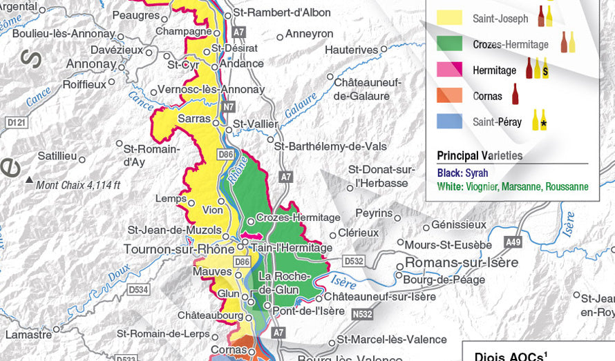
The Northern Rhône section of the Rhone Valley map represents one of the most distinctive wine-producing regions in France. Unlike the southern part, this area is characterized by steep slopes, narrow vineyard terraces, and a cooler continental climate. The map clearly shows how vineyards are concentrated along the riverbanks where sunlight exposure and soil composition create ideal conditions for grape varieties like Syrah and Viognier. This region is smaller but highly specialized in wine production.
On a detailed Rhone Valley map, key appellations such as Côte-Rôtie, Hermitage, Cornas, and Saint-Joseph are positioned along the river’s narrow corridor. These locations are closely clustered due to the limited available land suitable for viticulture. The map helps users understand why vineyards here are often built on slopes, as elevation plays a major role in sun exposure and drainage. This geographic arrangement is one of the reasons Northern Rhône wines are considered highly structured and complex.
The cities of Lyon, Vienne, and Valence act as important reference points on the Northern Rhône map. These urban centers connect rural wine areas with larger transportation networks, making the region more accessible for tourism and trade. The map also shows how proximity to the Rhône River influences settlement patterns, with most towns located directly along its banks for historical trade and agricultural advantages.
Southern Rhône Map Overview and Regional Wine Structure
The Southern Rhône region appears much broader and more open on the Rhone Valley map compared to the northern section. This area is characterized by wide plains, rolling hills, and a warmer Mediterranean climate. The geography allows for larger vineyard areas and more diverse grape blends, particularly Grenache-based wines. The map clearly shows how the river spreads out here, creating fertile agricultural zones that differ significantly from the steep terrain in the north.
Key wine regions such as Châteauneuf-du-Pape, Gigondas, Vacqueyras, and Côtes du Rhône are widely distributed across the Southern Rhône map. Unlike the compact structure of the north, these appellations are more spread out, reflecting the region’s broader geography. The map helps travelers understand how vineyard placement is influenced by factors such as soil type, river proximity, and wind exposure, especially the strong mistral winds that shape grape development.
Cities like Avignon, Nîmes, and Orange are important landmarks on the Southern Rhône map, serving as cultural and logistical hubs. These cities provide access to surrounding vineyards and historical sites, making them ideal bases for tourism. The map also highlights how the Rhône River branches into the Camargue delta, showing wetlands and natural reserves that add ecological diversity to the region.
Cities and Towns Across the Rhone Valley Map
The Rhone Valley map includes a series of important cities and towns that reflect the historical and economic significance of the region. In Switzerland, towns like Brig, Sion, and Geneva mark the upper course of the river, while in France, cities such as Lyon, Valence, Avignon, and Arles define the valley’s cultural and geographical progression. Each city is positioned strategically along the river, demonstrating how waterways influenced urban development throughout history.
Smaller towns like Tain-l’Hermitage and Tournon-sur-Rhône are also clearly marked on the Rhone Valley map, offering insight into the region’s wine-focused identity. These towns are closely associated with vineyard landscapes and often serve as entry points for wine tourism. The map helps visitors identify how these smaller settlements connect larger urban areas with rural wine-producing zones, creating a continuous cultural corridor along the Rhône River.
Understanding these cities through the map allows travelers to plan more efficient routes across the valley. Instead of viewing the region as isolated destinations, the Rhone Valley map shows how each city connects through road networks, river paths, and vineyard routes. This interconnected structure makes the region easier to explore and highlights its role as one of Europe’s most historically important travel corridors.
Vineyards and Wine Regions on the Rhone Valley Map
A key feature of the Rhone Valley map is its detailed representation of vineyard locations and wine appellations. The map shows how vineyards are distributed along the river based on climate differences, elevation, and soil diversity. Northern vineyards are concentrated on steep slopes, while southern vineyards are spread across flatter terrain. This contrast is essential for understanding the diversity of wines produced in the Rhône region.
Famous vineyards such as Château de Beaucastel, E. Guigal, and Domaine Jean-Louis Chave are often highlighted on advanced Rhone Valley maps. These estates represent the historical and cultural depth of the region’s winemaking tradition. The map helps wine enthusiasts locate these estates and understand their positioning relative to surrounding geography, rivers, and nearby towns.
In addition to famous estates, the Rhone Valley map also reveals lesser-known vineyards that contribute to the region’s overall wine diversity. These smaller producers often operate in micro-terroirs, where soil and climate conditions vary significantly within short distances. The map allows users to explore these hidden areas, making it a valuable tool for both tourism and wine education.
How to Use the Rhone Valley Map for Travel and Planning
Using a Rhone Valley map effectively requires understanding both its geographic and practical applications. For travelers, the map serves as a planning tool to organize wine tours, cultural visits, and transportation routes. It helps identify the most efficient paths between vineyards, cities, and scenic landmarks, reducing travel time while maximizing experience quality. Digital versions of the map also provide GPS integration for real-time navigation.
Seasonal planning is another important use of the Rhone Valley map. During harvest seasons, certain vineyards may be more accessible or offer special tours. The map helps visitors identify optimal travel windows and plan routes accordingly. It also allows users to balance wine tourism with cultural exploration, ensuring a well-rounded experience across the valley.
For educational and research purposes, the Rhone Valley map provides insight into how geography influences agriculture and settlement patterns. It demonstrates the relationship between natural landscapes and human activity in a structured way. Whether used digitally or in print, the map remains an essential resource for understanding one of Europe’s most dynamic river valleys.
FAQ: Rhone Valley Map Guide
1. What is a Rhone Valley map used for?
A Rhone Valley map is used to understand the geographic structure of the Rhône River region, including vineyards, cities, and natural landscapes. It helps travelers plan routes, explore wine regions, and study how geography influences agriculture and settlement patterns. It is especially useful for wine tourism and regional education.
2. Why is the Rhone Valley important for wine production?
The Rhône Valley is important because it offers diverse climates and terrains that support different grape varieties. The northern part produces structured wines like Syrah, while the southern part produces blended, fruit-driven wines. The Rhone Valley map helps visualize how these differences are shaped by geography.
3. What are the main regions shown on the Rhone Valley map?
The main regions include Northern Rhône and Southern Rhône. Northern Rhône is narrow and mountainous, while Southern Rhône is wide and flat. The map also highlights key wine appellations, cities, and river routes that connect the entire valley from Switzerland to the Mediterranean.
4. How does the Rhône River influence the region?
The Rhône River shapes climate, soil, and settlement patterns throughout the valley. It creates fertile agricultural zones and natural transportation routes. The Rhone Valley map shows how the river connects different regions and supports both wine production and urban development.
5. Is a digital or printed Rhone Valley map better?
Both formats are useful depending on purpose. Printed maps are great for overview and planning, while digital maps offer navigation, GPS tracking, and interactive features. Many travelers use both together for the most complete understanding of the Rhône Valley.
You may also read: How to Get to Mont Ventoux