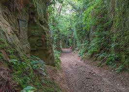
Tucked away in the rolling green hills of West Dorset lies a landscape feature that feels completely detached from the modern world: Shutes Lane. Located between the charming artisan village of Symondsbury and the bustling market town of Bridport, this historic holloway (sunken lane) is a breathtaking testament to human history and natural erosion.
Unlike standard walking trails, Shutes Lane offers an immersive journey beneath the roots of towering trees, flanked by dramatic sandstone walls that have been deeply carved by centuries of travelers, traders, and local characters.
If you are planning a trip to Dorset and want to experience something far more mysterious than the traditional Jurassic Coast beaches, this comprehensive, local guide will provide you with the deep history, essential practical travel details, walking routes, and unique insights required to explore Shutes Lane and its eerie neighbor, Hell Lane.
What is a Holloway? The Geomorphic Origins of Shutes Lane
To appreciate Shutes Lane, one must first understand what a “holloway” actually is. Derived from the Old English word “hola-weg”, meaning a sunken road, a holloway is a pathway that has dropped significantly below the level of the surrounding fields.
These astonishing formations do not happen overnight; they are the organic result of thousands of years of human and animal traffic combined with the natural elements. Shutes Lane is carved directly into the soft, golden Bridport Sands (part of the Inferior Oolite sandstone group dating back to the Jurassic period).
Over medieval generations—and potentially stretching back to the Iron Age—the constant friction of iron-rimmed cartwheels, heavy cattle hooves, and human boots wore down the soft stone. When heavy English rains swept through the region, these loose particles were washed away, turning the paths into natural drainage gullies. Over centuries, the road sank deeper and deeper. Today, the embankments of Shutes Lane rise up to 20 or 30 feet above the walker, creating a subterranean canyon or “green tunnel” effect where tree canopy roots twist across the open sky.
Deep History: Smugglers, Trade, and the “Rogue Male”
Historically, Shutes Lane was not a leisure trail; it was a vital artery for commerce. It connected the ancient agricultural settlements of Symondsbury, North Chideock, and the coastal ports.
The Smuggler’s Connection
During the 18th and 19th centuries, the Dorset coast was notorious for smuggling operations. Contraband goods such as brandy, tea, silk, and tobacco were landed on the dark shores of nearby Eype Mouth or Seatown. Smugglers needed discreet, hidden routes to transport these illegal goods inland to markets without being spotted by revenue officers riding along the high ridgelines. Because Shutes Lane is completely hidden from view unless you are standing directly inside it, it became a legendary route for local smuggling gangs who moved quietly under the cover of night.
Literary Fame: Rogue Male
Shutes Lane and the interconnected Hell Lane achieved profound literary fame in the 20th century. Celebrated author Geoffrey Household used these specific Dorset holloways as the primary setting for his iconic 1939 suspense novel, Rogue Male. In the book, an unnamed protagonist—who attempted to assassinate a European dictator—flees back to England and hides from secret agents by literally burrowing into the deep, overgrown banks of a Dorset holloway. The book has served as a massive inspiration for modern thriller writers, and ongoing cinematic interest keeps the legacy of these paths alive.
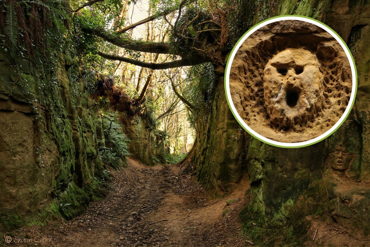
The Mystical Sandstone Carvings: From Folk Art to Modern Culture
What sets Shutes Lane completely apart from other holloways in the United Kingdom is the extraordinary collection of carvings etched directly into the mossy, damp sandstone banks. As you walk through the dimly lit trail, you will notice dozens of faces, figures, and abstract symbols staring back at you from the rock face. The atmosphere can feel intensely atmospheric, or even slightly haunting, depending on the time of day and the way the sunlight filters through the overhead leaf canopy.
Who Made the Carvings?
While some romantic local folklore suggests these carvings are ancient pagan symbols or protective medieval wards designed to ward off evil spirits, the reality is far more contemporary. The vast majority of the detailed art began appearing in the late 20th century. Local artists, bored children, and visiting walkers realized how soft and malleable the Bridport Sands were, using small sticks, knives, or keys to leave their mark.
The carvings are constantly evolving. Alongside intricate Celtic knots, Green Men, and mysterious gargoyles, sharp-eyed explorers will spot humorous modern additions—including a recognizable carving of Homer Simpson. Because the sandstone is highly susceptible to weathering and erosion, old carvings gradually dissolve over decades while new ones emerge, making Shutes Lane a living, breathing gallery of public art.
The Ultimate Shutes Lane & Hell Lane Circular Walk Route
To experience this geological wonder fully, it is highly recommended to complete the classic Shutes Lane and Hell Lane Circular Walk. This trail seamlessly links two of Dorset’s most impressive holloways into one unforgettable trek.
Walk Summary
- Distance: Approximately 4.5 miles (7.2 km)
- Time Required: 2 to 2.5 hours
- Difficulty: Moderate (Expect uneven terrain, exposed tree roots, and deep mud during winter or after heavy rain).
- Starting Point: Symondsbury Estate Visitor Centre.
Step-by-Step Navigation
- The Starting Point: Begin your journey at the Symondsbury Estate (Postcode: DT6 6HG). Here you can take advantage of the ample parking facilities and grab a morning coffee at the Symondsbury Kitchen.
- Entering Shutes Lane: Follow the signed public footpaths leading northwest out of the village toward the base of Colmers Hill (the iconic, tree-topped conical hill that dominates the local skyline). As you pass the lower fields, the path transitions quickly, dropping you down into the entrance of Shutes Lane.
- Exploring the Holloway: Spend time slowing down through this section. This is where the walls are highest, the moss is thickest, and the sandstone carvings are most densely populated. Take photographs, but please do not touch or alter the existing artwork.
- Transition to Hell Lane: As Shutes Lane begins to shallow out near the hamlet of North Chideock, follow the connecting trail signs that loop you eastward into Hell Lane. Despite its ominous name, Hell Lane is equally beautiful, offering an even narrower, wilder, and deeply atmospheric sunken trench experience.
- The Return Loop: The path eventually opens up onto high, panoramic ridgelines. From here, you are treated to breathtaking, unobstructed views of the Dorset countryside, Marshwood Vale, and the distant glittering sea. Follow the descending farm tracks back down into Symondsbury village to complete the loop.
Practical Information for Visitors (Parking, Facilities, Access)
To ensure a smooth, stress-free trip, keep these practical local travel details in mind before you head out:
- Parking: Free parking is available at the Symondsbury Estate Visitor Centre. It is the safest and most convenient place to leave your vehicle, as parking directly on the narrow lanes near the holloway entrance is highly discouraged and dangerous for agricultural machinery.
- Footwear: Do not attempt this walk in casual sneakers or sandals. Due to the high walls and deep shade, Shutes Lane retains moisture long after rain has stopped. It can become an absolute quagmire of thick mud. High-quality waterproof hiking boots are an absolute necessity.
- Accessibility: Due to the severe nature of the terrain—including deep ruts, exposed rocks, steep inclines, and muddy patches—Shutes Lane is completely unsuitable for wheelchairs, pushchairs, or individuals with limited physical mobility.
- Dog-Friendly: Dogs are absolutely welcome on this route. However, please ensure they are kept on a lead when transitioning from the holloways onto the open ridge paths, as you will be passing through active farmland containing sheep and cattle.
- Amenities: There are no public toilets or shops within the holloways themselves. Public facilities, excellent local food, and a farm shop are all clustered at the Symondsbury Estate.
Safety and Conservation: Preserving the Sunken Lanes
As Shutes Lane has grown in popularity on social media platforms like Instagram and TikTok, the influx of visitors has put a strain on this delicate environment. local conservation efforts emphasize the importance of responsible tourism when visiting the holloways.
The root systems of the ancient trees overhead are what hold the high mud and sandstone banks together. Scrambling up the steep embankments or pulling at exposed roots loosens the soil, causing significant structural damage and landslide risks. Visitors are requested to stay strictly on the floor of the pathway. Additionally, leaving plastic waste or litter in the lanes ruins the timeless, eerie charm for others, so please follow the “Leave No Trace” principle.
Frequently Asked Questions (FAQs)
Where exactly is Shutes Lane located?
Shutes Lane is situated in West Dorset, South West England. It runs between the village of Symondsbury and the town of Bridport, roughly 2 miles inland from the Jurassic Coast.
Where can I park to visit Shutes Lane?
The best and safest place to park is at the Symondsbury Estate Visitor Centre parking lot (Postcode: DT6 6HG). Parking here is free, secure, and places you right at the official trailhead for the circular holloway walks.
Is the Shutes Lane walk safe for children?
Yes, older children generally find the holloway walk incredibly exciting due to the high walls and hidden sandstone faces. However, parents should monitor young children closely, as the trail features exposed tree roots, uneven rocks, slippery mud patches, and steep slopes.
Can I create my own rock carving in Shutes Lane?
While the carvings are an ongoing phenomenon, visitors are strongly urged to respect the natural landscape and avoid carving into the stone. The sandstone walls are highly delicate, and excessive carving accelerates environmental erosion, threatening the ancient trees.
How long does it take to walk through Shutes Lane?
If you are only walking through Shutes Lane itself, it takes about 20 to 30 minutes of slow exploration. If you are completing the full Shutes Lane and Hell Lane Circular Walk loop, expect the hike to take between 2 and 2.5 hours.
Is there mobile phone signal inside the holloway?
Mobile phone reception can be incredibly weak or completely non-existent once you descend deep into the heart of Shutes Lane due to the towering 30-foot earthen walls and dense overhanging forest canopy. It is highly recommended to download an offline map or map PDF before you begin your journey.
You may also read: pogeo